Sources for Wind Data
Go beyond the GRIB
So, “what exactly am I looking at here…”
My favorite question from a client or student is “So, What exactly am I looking at here” because it means they are engaged in the information and want to know the why and how, and not just the what of a question.
This blog post is aimed at discussing what we are looking at with different available sources of weather data as well as how to access those sources.
We discuss in classes like Ground School that when looking at weather data, it falls into three categories.
Observation < -> Forecast <-> Model
(Objective Measure)->(Interpreted)->(Theoretical)
Models
A model is a set of solutions to fluid and atmospheric dynamics equations based on known boundary conditions from some sample set of observations.
It represents theoretical wind values at certain points, the density of the points is referred to as the resolution of the model. Therefore higher the resolution, the larger the data file for a given geographic area.
The inputs are observed conditions that come from weather stations, satellite images, ship station reports, ...
This blog post is a high level overview, but if you are interested in the details of the GFS v16 release, the announcement for v16 from March 2021 is a good place to start.
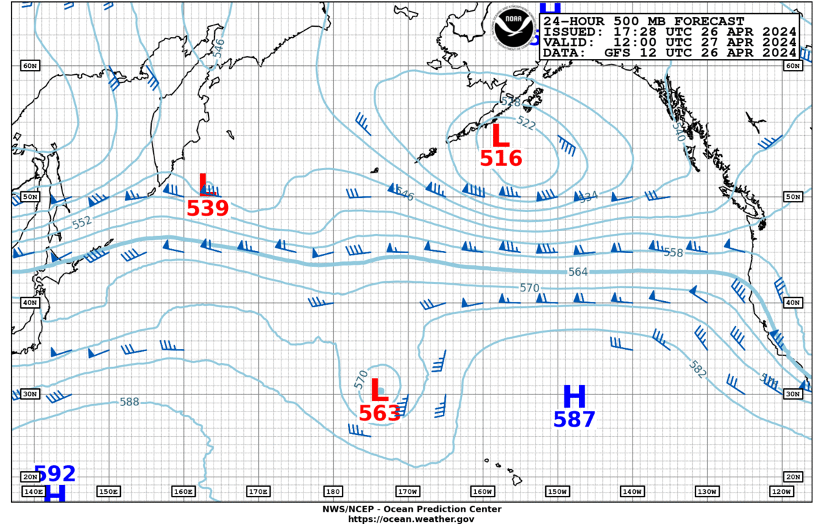
Once the observation snapshot is captured, the model run starts and it takes time to run the full solution set. So the 0000UTC observations become available a few hours later, generally about 3-6 hours after the observations time. The output is a generally viewed as a visual representation of the model’s GRIB encoded binary output, and shows the theoretical wind possibilities.
As a personal note, I usually try to view a GRIB as wind barbs, because in good tools, the tool draws the barbs at particular locations for which they were calculated.
I have found that viewing a GRIB as wind streams obscures the calculated locations in such a way that if there is geography, heating, or cooling between my boat and the calculated point, it is generally not picked up.
I have seen this cause people and tools to make some errors in their assumptions about the data as a result.
Here are some common models with resolution and update frequency:
GFS - 22km resolution, every 6 hrs
ICON - 13km resolution, every 6 h
ECMWF - 9km resolution, every 12h
NAM - 5km, every 12h
HRRR - 0.03km resolution, hourly
ICON EU - 7km resolution, every 6h
AROME - 1.3km resolution, every 6h
There are commercial models available
Forecasts
Once the models are computed a forecaster views the many outputs of a model, or many models to formulate a forecast based on things like:
Model agreement - is the same thing showing up in multiple outputs
More recent observations - along the coast especially, it’s possible to look at weather stations and see if the calculated theoretical weather is being observed.
Local knowledge - A forecaster works an area day to day, and develops an acumen for given model accuracy over that area.
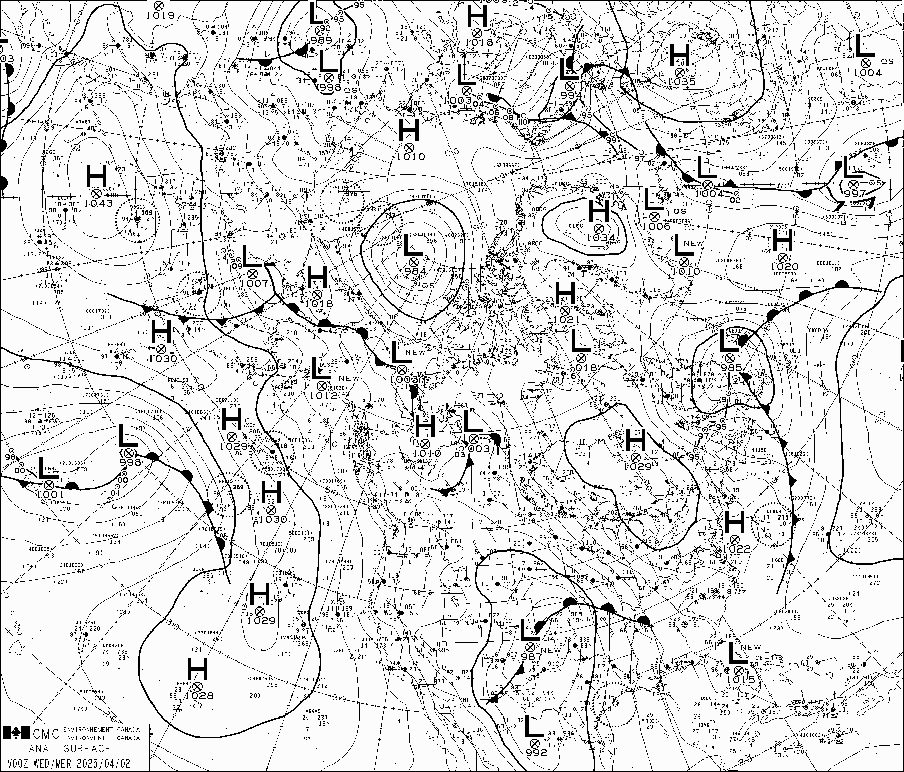
As the forecasts are created, there is also a corresponding surface analysis created. I have included the ones I commonly use below. Right now I am particularly focused on East Pacific and East Pacific Tropical sources. As an aside, note the cool wind speed relative to isobar distance graph on the met office chart.
Japan Meteorological East Pacific Surface Analysis
Met Office North Atlantic Surface Analysis
Australian Bureau of Meteorology
Environment Canada Northern Hemisphere 700MB
There is generally a text version of most forecasts, for a comprehensive discussion on these sources, David Burch’s Modern Marine Weather has excellent sections with comprehensive lists of different text sources.
The forecasts I use primarily are the National Weather Service west coast zone forecasts. I have memorized them and their sail docs strings for quick access just because of the work I do presently.
Sailing from Seattle to San Diego for instance, you pass through the following zones
Zone - Region - Saildocs string
KSEW - Seattle - send FZUS56.KSEW
KPQR - Portland - send FZUS56.KPQR
KMFR - Medford - send FZUS56.KMFR
KEKA - Eureka - send FZUS56.KEKA
KMTR - SF/Santa Cruz/Monterey - send FZUS56.KMTR
KLOX - Monterrey to LA - send FZUS56.KLOX
KSGX - San Diego - send FZUS56.KSGX
When crossing the Pacific for the west coast USA ocean deliveries/races I use primarily the forecast that incorporates forecasts from OPC discussion for the Eastern Pacific, NHC Tropical Discussion, and NWS Honolulu Forecasts. If there is other information I am looking for I will bring in other forecasts as well.
East pacific combined forecast
send FZPN02.KWBC
Finally, hurricanes. Individual named storms are given a forecast zone number and updates can be retrieved using that number.
While assisting in routing Erden Eruc this summer we had a heck of a time with Hurricane Linda. Linda was given the Forecast identifier WTPZ42.KNHC.
For updates, in saildocs I simply send
sub WTPZ42.KNHC - note that this is for Linda’s identifier at the time. One would need to retrieve the string for the storm of interest.
These forecasts are essential as they give a discussion of the progression of the storm, it’s heading, and it’s GPS positions with wind speeds and timings. I have included update 11 for Linda below. Pay particular attention to the final section.
--------------- WTPZ42 KNHC 122035 TCDEP2 Hurricane Linda Discussion Number 11 NWS National Hurricane Center Miami FL EP122021 3 PM MDT Thu Aug 12 2021 There hasn't been much change to Linda's structure since this
morning. The hurricane's center is embedded within a small Central
Dense Overcast, and a dimple is evident in visible satellite images
where an eye would be likely to form. For the most part, satellite
intensity estimates have not changed from this morning, and a 1550
UTC ASCAT-A pass showed peak winds in the 55-60 kt range. Given
that instrument's typical undersampling, especially for a small
cyclone, the 65-kt initial intensity still seems appropriate.
Linda is moving toward the west-northwest, or 300/8 kt, to the
south of a mid-tropospheric ridge located over northern Mexico.
This ridge, and a stronger mid-level high developing over the
western United States, are expected to continue driving Linda
toward the west-northwest for the next 2-3 days. By days 4 and 5,
another mid-level high is forecast to develop between Hawaii and
Alaska, and that feature is likely to block Linda's northward
progress, and possibly even cause a south-of-due-west motion by the
end of the forecast period. The track guidance is in good
agreement on this scenario, and the updated NHC track forecast has
been nudged southward mainly on days 4 and 5. It should be noted
that this new forecast is not as far south as several of the track
models, and additional southward adjustments may be required in
subsequent forecasts.
Various shear analyses suggest that the northerly shear affecting
Linda may have decreased slightly, with the magnitude now on the
order of 10-15 kt. SHIPS diagnostics indicate that this level of
shear is likely to continue for another 24 hours or so, and then it
could decrease further and enable some gradual strengthening.
Models generally show Linda's intensity peaking and leveling off in
the 36-60 hour window. After 60 hours, Linda is expected to move
into a less favorable thermodynamic environment, highlighted by
colder sea surface temperatures and drier, more stable air, and
weakening is therefore shown on days 3-5. One important note is
that further southward shifts in the forecast track would keep
Linda over warmer waters and potentially slow the cyclone's
weakening trend.
FORECAST POSITIONS AND MAX WINDS
INIT 12/2100Z 15.3N 108.7W 65 KT 75 MPH
12H 13/0600Z 16.0N 110.3W 70 KT 80 MPH
24H 13/1800Z 17.0N 112.4W 75 KT 85 MPH
36H 14/0600Z 17.9N 114.6W 80 KT 90 MPH
48H 14/1800Z 18.7N 116.8W 80 KT 90 MPH
60H 15/0600Z 19.0N 118.8W 80 KT 90 MPH
72H 15/1800Z 19.0N 120.8W 75 KT 85 MPH
96H 16/1800Z 18.6N 124.5W 65 KT 75 MPH
120H 17/1800Z 18.5N 128.3W 55 KT 65 MPH
$$
Forecaster Berg
NNNN
---------------
Observation
Observations are truly the key to successfully navigating the weather aspect of the trip.
As the departure date approaches, begin analyzing how close the forecast is to the conditions observed and how observations differ from forecast and model analysis to date.
A few years ago, we were arriving into Westport and we noticed that the winds, which should have been from the north, based on forecast, were actually coming from the west. This is important because it means the pressure system didn’t land where the forecast had estimated it should. The first course of action of course is to validate the observation.
My sources for validating nowcast observations start with my own instruments. I have a barometer(for atmos pressure) and anenometer(wind speed, temp, wind direction) onboard. I also have a watch that can log the barometric pressure history and trend.
If I need to look at outside data to analyze a larger area, a few of the tools I use are:
Buoy Data, Ship Station Reports - National Data Buoy Center
Spot forecasts from - digital.weather.gov
Satellite Information - GOES 17 website (Lightning)
AIS Position Data - Marine Traffic
In upcoming blogs we will talk about how to combine all of this into a workable plan for a race, crossing, or delivery.
Please feel free to sign up for updates